Archive L760
![]()
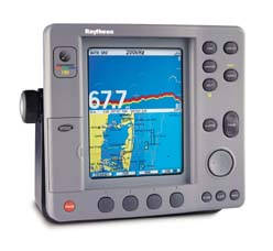
The L760 color fishfinder uses the very latest processor and sonar technology for the most accurate performance and echo detection. With 600 Watts output power and dual frequency operation the L760 provides unmatched performance from 1 to 2,700 ft. A feast of features make the L760 the choice for serious fishing:
- Target detection as sonar echo
- Full or split screen display of either frequency, digital or chart information
- User defined windows for digital information display
- Total screen refresh when changing depth scales
- Adjustable color thresholds
- Ability to place a waypoint on a fish target using the cursor
The L760 includes a full C-Map NT chartplotter and Raytheon’s award winning High Speed Bus (HSB) technology, adding fishfinder capabilities to the 7 and 10 inch HSB radar and Raychart 520/530 products. The L760 can be interfaced with any Pathfinder HSB radar to produce a full color radar at one station, even if that station is in bright sunshine.
Technical Specifications
Display Type
7″ Color TFT LCD
Controls
11 defined keys, 4 soft keys and trackpad
Cursor
Context sensitive, provides range/bearing or Lat/Lon
Resolution
640 x 480
Viewing Area
7″ diagonal (136 x 100mm)
Illumination
Screen: Continuous (128 levels of backlight)
Keypad: 3 levels of backlighting
Size
222mm x 204mm x 152mm
(8.8″ x 8″ x 6″)
Weight
8.1lbs (3.7kg)
Mounting
Trunnion bracket with panel option
Operating Temperature
10°C to +50°C
Humidity limit: Up to 95% at 35degC
Waterproof
U.S.C.G. CFR-46 standards
Approvals
CE – conforms to 89/336/EEC (EMC), EN0945:1997
FCC – conforms to Part 80 (47CFR) and Part 2 (47CFR)
Languages
UK English, US English, Danish, French, German, Dutch, Italian, Icelandic, Norwegian, Portuguese, Spanish, Swedish, Finnish
Repeater Capabilities (High Speed Bus)
Fully independent use of remote Chart data if present on HSB. Full remote control and display of Radar data if present on HSB
Cursor Echo
Cursor echo between radar and chart on split screen and/or separate displays connected via Seatalk
Interfaces
1 x HSB in/out, 1 x Seatalk in/out,
1 x NMEA 0183 out, 2 x NMEA 0183 in,
2 x C-map cartridge slots
Man Overboard (MOB Mode)
Mark placed with course line; readout shows range, bearing, Lat/Lon of MOB and time elapsed since MOB
Screen Functions
Full, half and quarter screens available dependant on function providing Radar and Chart via HSB (if data available), Radar Zoom, BDI, CDI and Nav Data
Data Boxes
Up to six user selectable information boxes
Sounder Features
Output Power
600 Watt output (RMS)
Frequency
Dual Frequency – 50KHz / 200KHz
Max. Depth
2,700ft (820m)
Transducer Type
Balanced transducer and Front End TX/RX
Screen Update
Full screen update – sounder image recalculated to new range at range shift. No chopped bottom
Control Features
Auto Gain, Range, Frequency Select, Zoom, Color Threshold
Display
Downlock, A-scope, Zoom, Bottom Lock, Speed and Temp.
Chartplotter Features
Cartography
C-MAP’s NT micro cartridges available from C-MAP. World Map built in
Display Windows
Chart, data, BDI, CDI, Navdata
Chart Scaling
1/64nm (if cartographic data is available) to 4000nm
Presentation Modes
North up (selectable True or Magnetic) Head up or Course up
Waypoints
1000 waypoints entered via cursor, Lat/Lon, range and bearing from present position or at vessel’s position. 16 character names can be assigned
Waypoint Transfer
HSB, current route via Seatalk, NMEA
Routes
A route plan may contain up to 50 waypoints. Up to 20 routes can be stored in the units internal memory
Track History
5 tracks with up to 750 points in each can be stored in the units internal memory
Alarms
Programmable arrival, cross track error, anchor drift, position fix / data loss warning, countdown timer and alarm clock
Navigation Information
Own ships position in Lat/Lon, XTE, TTG and SOG/COG selectable. Mileage scale ruler. Bearing and distance to waypoint. Bearing and distance to cursor, Seatalk data as above
Variation Source
Auto (SeaTalk/NMEA/Internal algorithm) or Manual
Chart/Radar Synchronisation
User selectable in split screen mode provided radar data available
Click here to see Archive Products